

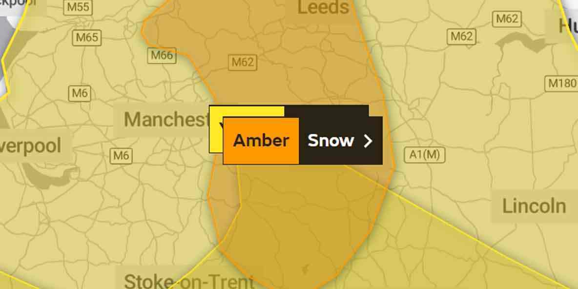
An Amber warning for snow has been issued for central and northern England, including Salford and Greater Manchester.
It will remain largely cloudy over the coming days, with the best of the clear spells further north which will result in frost on the ground. Outbreaks of rain, sleet and snow will linger across the south of the country but will, gradually move up across the country and the hours pass.
As the milder air moves north, the area at risk of snow transitions north with it. A number of National Severe Weather Warnings are in place across the UK as snow continues to cause disruption through the week.
An Amber warning for snow has been issued covering an area from the south of the Peak District up to the North Pennines, valid from 1500 Thursday to 1200 Friday.
Salford is included in this warning.
10-20cm of snow is likely to fall across much of the area, with 30-40cm in some higher up places, and may possibly be accompanied by strong winds.
Thursday will see the weather turn even more unsettled as another band of rain, sleet and snow moves northwards. With strong winds, blizzard conditions are likely, especially over higher ground. It will feel especially cold with a maximum temperature of just 5 °C.
There will be a little respite on Friday as skies clear, but Rain, sleet, but after a dry start Saturday will bring further rain, sleet, with snow possible in the evening into Sunday.


Recommended Comments
There are no comments to display.
Create an account or sign in to comment
You need to be a member in order to leave a comment
Create an account
Sign up for a new account in our community. It's easy!
Register a new accountSign in
Already have an account? Sign in here.
Sign In Now