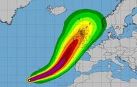
The MET Office has updated its predictions for ex-Hurricane Ophelia as it tracks across the Atlantic en-route to the UK.
Severe weather alerts have been issued with warnings of potential power cuts as well as damage to buildings across the region.
On its present predicted course the bulk of the storm will hit Ireland in the early hours of Monday (15/10) morning.

Salford stands to miss the worst of the storm but after a breezy start on Monday, winds will strengthen throughout the day, with strong gales across most parts in the afternoon.
It will stay largely cloudy any mostly dry; some brighter spells are possible towards late afternoon with a maximum temperature of an unseasonably warm 21 °C caused by a plume of hot air from the continent.
The coming storm coincides with the 30th anniversary of the Great Storm of 1987, which caused an estimated £1 billion worth of damage and sadly cost 18 lives.
So it is advised to take precautions when traveling, keep speeds down and expect the possibility of travel disruption across local networks.
Edited by KARL


Recommended Comments
There are no comments to display.
Create an account or sign in to comment
You need to be a member in order to leave a comment
Create an account
Sign up for a new account in our community. It's easy!
Register a new accountSign in
Already have an account? Sign in here.
Sign In Now