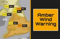
An upgraded severe weather warning has been issued for much of the country including the North West which is set to take the brunt of a battering from storm Ciara as it thunders eastward towards us over-night and through into tomorrow (Sunday 9th Feb).
Heavy rain and very strong winds with gusts of up to 80mph are expected to impact the region between 8am and 9pm tomorrow and travel bosses have warned of disruption to roads, rail and air as they issued a warning calling upon people to only travel if absolutely necessary.
Drivers are being warned to take extreme care on roads and to those in high-sided vehicles should avoid exposed areas and high bridges where the winds will be at their strongest. Reduce speeds and ensure there is enough room in front of you, also be careful when passing high-sided vehicles.
Those travelling on foot should be watchful for flying debris, such as roof tiles.
A spokesperson for the RAC has described the conditions as 'Black Sunday for travel'.
As the 1000-mile-wide storm pushes towards us the mercury will also plummet to as low as -5deg in some areas and there is a change that snow may fall on higher ground.
Ciara is predicted to be the strongest storm to hit the UK in seven years and power networks are preparing to deal with blackouts and electrical supply disruption as over-head power lines go down in the high winds.
A Met Office spokesman, Frank Saunders has said:
Quote
“Storm Ciara will bring damaging winds and heavy rain across the UK this weekend and we have issued a range of severe weather warnings giving people time to prepare for potential impacts of the storm.
“Winds will increase through Saturday across Northern Ireland, Scotland, northern England and Wales, before turning very windy across the rest of UK through the early hours of Sunday morning.
“Gusts of 50 to 60 mph are expected quite widely across inland areas, with even stronger gusts of 80mph or higher along coastal areas, especially in southeast England and northern Scotland.
“In the wake of Storm Ciara, it’ll remain unsettled and very windy across the UK and it’ll turn colder with wintry showers and ice an additional hazard, as we head into the new week.”
Edited by KARL














Recommended Comments
There are no comments to display.
Create an account or sign in to comment
You need to be a member in order to leave a comment
Create an account
Sign up for a new account in our community. It's easy!
Register a new accountSign in
Already have an account? Sign in here.
Sign In Now